Steel rungs feel cold under your hands. Thirty feet up, mountains roll away like wrinkled paper. Rich Mountain Fire Tower perches right where North Carolina meets Tennessee. Built in 1932, this lookout has weathered nearly a century of storms. Today, it gives hikers some of the best views in the Southern Appalachians. The 3,643-foot summit puts you above most surrounding peaks. One foot in each state—literally.
Key Takeaways
- This 1932 fire tower sits at 3,643 feet with views across two states. The restored steel structure lets you safely climb above the treeline.
- Hike 5 miles total or drive most of the way. The Appalachian Trail route challenges you, while gravel roads get cars close.
- Each season brings different rewards. Spring flowers, summer storms, fall colors, winter clarity.
- Hot Springs waits below with healing waters. Soak tired muscles in natural thermal pools after your climb.
- Real fire watchers lived here for decades. You’re standing where people spent months alone protecting these forests.
Tower History
Fire watchers once called this place home. They lived in a tiny cabin atop the steel frame, scanning horizons for smoke. Lonely work. Dangerous work. One missed fire could burn thousands of acres.
The Forest Service built this tower in 1932. Watchers stayed here through the 1990s when planes took over fire spotting. Most towers got torn down after that. Rich Mountain barely survived.
By 2017, the structure was falling apart. Storms and vandals had done serious damage. Then several groups stepped up—Forest Service, Appalachian Trail folks, fire lookout preservationists. They raised over $100,000 for repairs.
New stairs replaced the old death trap. Fresh paint covered rust spots. Vandal-proof materials went in. Now it’s one of six climbable towers left on the AT between here and Tennessee.
The trap door to the old cabin stays open year-round. Peek inside if you want. Just remember people lived up there for months at a time.
Getting Up There
Trail Route Park at Tanyard Gap in the small lot before the highway bridge. White blazes mark the Appalachian Trail going north—opposite direction from the bridge. No fire tower signs exist, but those white paint marks on trees won’t steer you wrong.
Five miles round-trip. You’ll climb 1,446 feet. Most people need 3-4 hours. The trail gets steep but gives you breaks between tough sections.
Drive Up High-clearance vehicles can take the back way. At Tanyard Gap, turn right instead of left. Follow old pavement downhill briefly, then turn left on gravel. Six winding miles puts you within 100 feet of the tower.
Road stays open April through November unless snow blocks it. Go slow—it’s narrow with few passing spots.
Directions: Asheville: US 25/70 north 23 miles from I-26, left at NC 208 to stay on highway, 1.9 more miles to Tanyard Gap Hot Springs: Northeast on US 25/70 about 3 miles
Trail Details
White rectangles painted on trees mark your path. Standard Appalachian forest—oaks, maples, some big old hemlocks. Small streams cross the trail. Nothing you can’t step over.
Rhododendron grows thick in spots, creating tunnels. Blooms in late May turn the trail into a flower show. Rocky sections use tree roots as natural stairs. Can get slippery when wet.
Bears live here year-round. Make noise. Don’t leave food around. Deer wander through regularly. Hawks circle overhead. Spring brings wildflower carpets—white trilliums everywhere. This trail connects you with nature in ways that support meditation in nature, letting the forest sounds quiet your mind as you climb.
At 2.4 miles, blue blazes branch left from the main trail. Small sign points to the tower. Final tenth-mile climbs straight up to the summit.
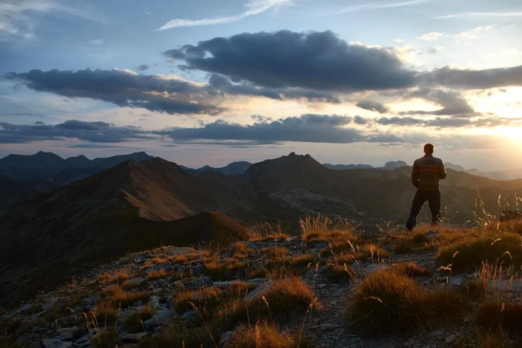
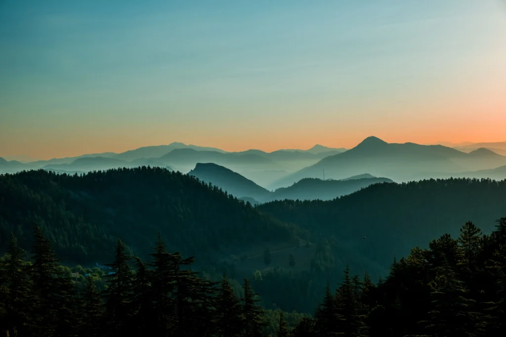
Views from the Top
The platform gives you the full 360. West into Tennessee shows rolling hills fading to the Cumberland Mountains. Great Smokies dominate the south with their blue haze.
Down south you can spot Hot Springs in the French Broad River valley. Those are the famous lookout tower hot springs people have visited for over 200 years. East reveals North Carolina’s highest country—Black Mountains with Mount Mitchell on clear days.
North shows Tennessee farmland and valleys. Different landscape from the forested ridges in other directions.
Morning light works best for photos. Late afternoon creates dramatic ridge shadows. Fall air stays clearest for distance viewing. Summer’s thick leaves make a green ocean below.
Hot Springs Connection
Natural thermal springs sit right below in the valley. Hot Springs Resort maintains pools at 100-104°F year-round. Perfect for sore muscles after the mountain fire lookout tower climb.
Native Americans used these waters long before Europeans arrived. The same geological forces that built Rich Mountain created these healing pools.
For longer mountain retreats, consider our Mountain Retreats in North Carolina to extend your wilderness time.
Seasonal Guide
Spring (April-June) Wildflowers bloom everywhere. Streams run higher from snowmelt. Afternoon thunderstorms common. Pack rain gear. Mud likely but manageable.
Summer (July-September)
Start early—heat builds fast. Dense canopy provides shade but traps humidity. Bring extra water. Ticks active. Afternoon storms typical.
Fall (October-November) Peak season for views and crowds. Best foliage colors. Temperature swings require layers. Clearest air all year.
Winter (December-March) Road closes—hiking only. Snow possible but not guaranteed. Fewer people. Excellent visibility when cold fronts clear the air.
Pack List
Always:
- Water (2-3 bottles)
- Energy snacks
- Rain jacket
- Extra layer
- First aid basics
- Light source
Seasonal: Spring: waterproof boots Summer: sun hat, bug spray Fall: warm gloves, camera Winter: full cold gear, boot traction
Camping and Rules
National forest allows dispersed camping. Set up 200+ feet from trails and water. Use existing sites when possible.
Fire restrictions change with drought conditions. Check current rules before your trip. When allowed, keep fires small. Drown completely before leaving.
Pack out all trash. Stay on marked paths. Small groups cause less damage.
Before You Go
Check weather forecasts. Mountain conditions change fast. Tell someone your plans—cell service gets spotty up there.
This fire tower hike rewards effort with views you’ll remember for years. Standing where fire watchers once protected these forests connects you to mountain history. The climb challenges your legs. The views challenge your camera.
Rich Mountain Fire Tower proves the best things require work to reach them. The area offers other rewarding mountain hiking opportunities and connects to the broader network of blue ridge hiking trails that make this region special for outdoor enthusiasts.
FAQ
Can you camp near Rich Mountain Fire Tower?
Yes, dispersed camping works in the national forest. Stay 200+ feet from trails and water sources, use existing sites when possible.
Is Rich Mountain Fire Tower safe to climb?
The 2018 restoration included new stairs and safety upgrades. It’s one of the sturdier public-access towers, but use basic climbing sense.
When should I hike to Rich Mountain Fire Tower?
Fall offers clearest views and peak colors. Spring has wildflowers with smaller crowds. Summer needs early starts due to heat.
How hard is the Rich Mountain fire tower hike?
Five miles total with 1,446 feet of climbing. Most fit hikers finish in 3-4 hours. Moderate difficulty with some steep sections.
Can I drive to the tower?
Yes, if you have high clearance. Six-mile gravel road works April-November depending on conditions. Narrow with limited passing spots.


